1 Salsomaggiore
2 Campore
3 San Rocchino-Costa Marenga
4 Salsominore
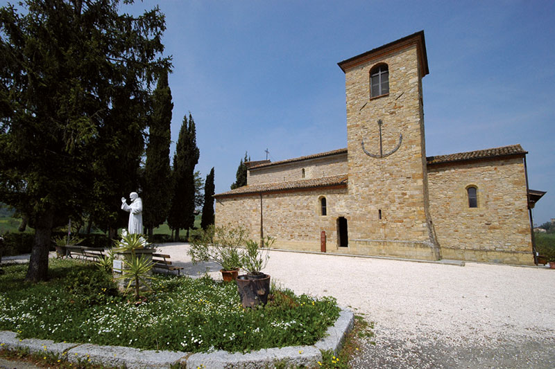
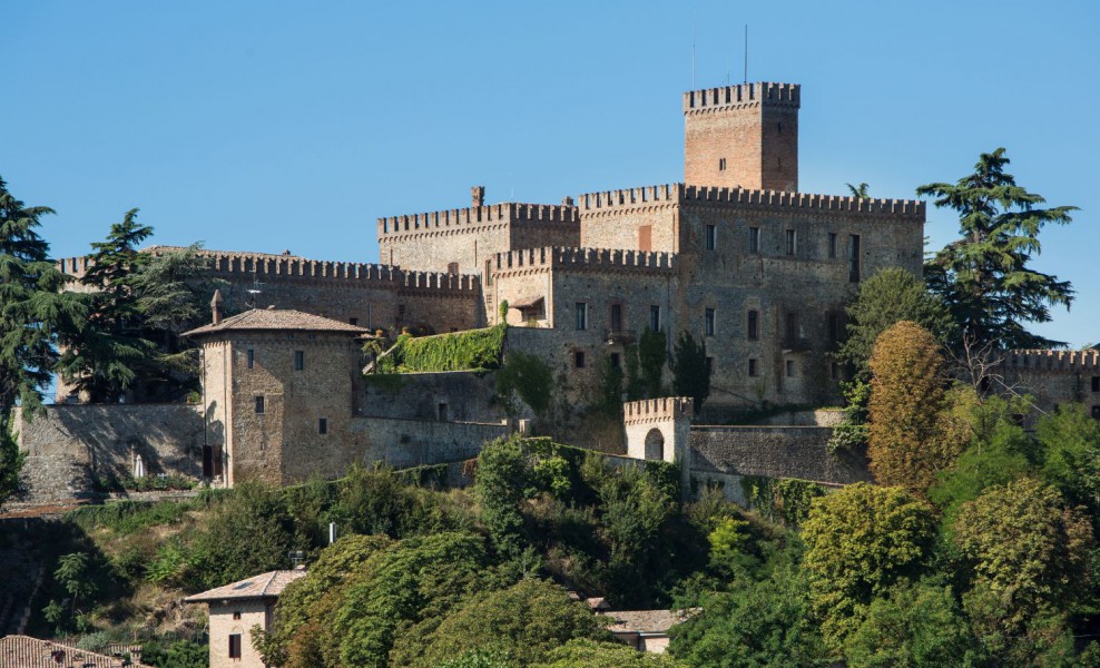
5 Scipione Castello
6 Scipione Ponte
7 Case Passeri
8 Vigoleno
10 Contignaco
11 San Vittore
12 Tabiano Castello
13 Bargone
14 Campore
15 Salsomaggiore – Terme Berzieri
16 Salsomaggiore
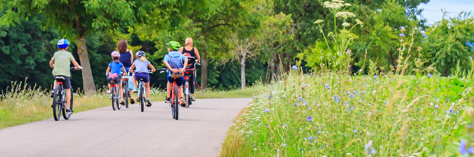
Departure from the parking in Via Del Lavoro, lot in front of the Zoja Baths. Head to the bike path that runs along the Ghiara stream; from the Railway Station enter the route and follow the bike path to the municipal bus depot in Via dei Gelsi. After having traveled (doing) all the bike path, go out on the provincial road and enter the uphill road that leads in the direction of Costa Marenga, a couple of km of ascent to get to the top of the hill and admire the view. Continue on asphalt and pass the group of houses in The San Rocchino area, then proceed on the path indicated by the CAI tables (path P1). Downhill, surrounded by vegetation you will arrive in the small hamlet of Salsominore where the remains of one of the Ancient Salts are located, also called "Portici del Sale"; looking up you will be able to see the bell tower of the Church of Christ the Savior. Next a few meters and on the left a dirt road will take you on a stretch of track off asphalt, completely immersed in the hills. Arrive at the village of Castello di Scipione, where you will find the manor of the Marquis Pallavicino (visitable) from whose main tower you can see, on clear skies, the profiles of Parma, Piacenza and Cremona. One more stretch between the vegetation and the dirt road, downhill, passing near the Osteria del Castello and passing through Case Boselli, then continue left towards SP57 towards Vigoleno (SP109). Past the Trattoria Cavallo, at the crossroads, keep the right along the provincial, you will reach at the "La Bocca" stop area in the Stirone River Regional Park, where you can take a break between the lush vegetation of the park, among the trees of poplars, elms, oaks, cherry trees, plums and hawthorns. After the stop, resume the path on the path that runs along the course of the Stirone stream, where you can face the single track among the trees of the riparian forest, which will allow you to see the fossil outcrops dating back to the period of the Late Miocene (8 million years ago). At the end of the route you will reach the area "Three Poplar trees", enter on the dirt road on the left, which leads on the SP109 and continue in the direction of Vigoleno. Take your breath, climb the gears and climb up the hills to the village of Vigoleno Castle, of which you can admire the walls and the impeccable integrity of the defensive system. Enter the inner courtyard where you can admire the keep (visitable) and if you are hungry you will find refreshment at the inns of the village. After the stop, continue downhill towards Case Sozzi, the road, a roadway that flanks the ridge, will lead, between characteristic hilly views and rows of vineyards, downstream to Villa resorts. After the descent, follow the asphalt along the bed of the Stirone stream, The route will guide you further and further downstream, crossing the Stirone stream on the bridge of Case Passeri, and then continue on the dirt road that passes next to BlackStone a (ofiolite) - rocky outcrop, testimony to the geological transformations of the Apennine - and the pond below formed by a natural spring. Follow the dirt track and climb to Cangelasio Costa alongside Mount Combu. Once you arrive in Costa, a short stretch of asphalt uphill, it will take you to the mouth of a new dirt descent. Continue the hike between dirt roads and paths between the hills, skirting the slopes of Mount Pianazzo. You will arrive on the asphalt in locality Piè di Via (the way footer). On the last leg of the route you can see on the left the Castello di Contignaco, built by the Pallavicino in the 11th century, the stronghold can be visited and offers tasting of local wines produced by the winery. Continue to the Romanic Pieve of St. John, perched on the top of a hill. Continue uphill following the main road that from asphalt turns into dirt, arrived at the top ready for a descent, with to the left a thick bush and on the right bucolic glimpses of the valley. The route will lead to San Vittore to continue on the Boffalora road. Pedaling through rolling hills, you can walk 5 km evenly divided between ascent and descent that will lead you to the village of Tabiano Castello. You will meet on the street the Church dating back to the sixteenth century dedicated to Saints Gervasio and Protasio. The Castle of Tabiano (visitable) was owned by the Marquis Pallavicino, survived the struggles between Guelphs and Ghibellini is now a private residence open to the public. You can admire the Watchtower which with the drawbridge forms the main access to the Castle: The upper part of the village is characterized by the walls built between the 12th and 13th centuries to defend the castle. In the quaint small village there is the possibility of a stop in the adjacent inn. Resume the route, continue downstream to reach Colombaia where you can climb back on asphalt to locality Variatico. After a couple of km the asphalt gives way to the double-track that will take you to the road of Bargone and from there to the castle of the same name, the last stronghold Pallavicina that you will meet on this route, now private property. In the forecourt in front of the castle the Church dedicated to the Assumption that houses a wooden statue of Blessed Orlando; Every year on the occasion of the Holy, many citizens accompany their pets for the annual blessing. And then down the last path nestled in the greenery, towards Salsomaggiore Terme with the arrival and conclusion of this excursion. In Salsomaggiore you can visit some historical places of the city: the Railway Station, Park Mazzini built in the early 1900s and going up the long park arrive in Piazza Lorenzo Berzieri with the magnificent Palace in the style of Liberty, the Well Scotti drilled in the late 1800s for the extraction of salsobromoiod waters. It's ideal to stop by enjoying a delicious artisanal ice cream.
Elevation profile

Crossed locations
- 1 Salsomaggiore- Start 0,0 km
- 2 Campore3,7 km
- 3 San Rocchino-Costa Marenga5,0 km
- 4 Salsominore6,8 km
- 5 Scipione Castello9,0 km
- 6 Scipione Ponte10,1 km
- 7 Case Passeri14,6 km
- 8 Vigoleno21,7 km
- 9 Cangelasio Costa28,2 km
- 10 Contignaco35,1 km
- 11 San Vittore38,3 km
- 12 Tabiano Castello43,4 km
- 13 Bargone52,0 km
- 14 Campore54,9 km
- 15 Salsomaggiore – Terme Berzieri56,1 km
- 16 Salsomaggiore- Arrival 57,1 km
Itinerary highlights
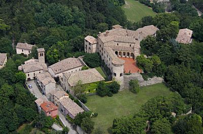
Castle of Scipione
The Castle of Scipione of the Pallavicino Marquees is the most ancient castle of the region and the only one still inhabitated by the descendants of the Pallavicino family.
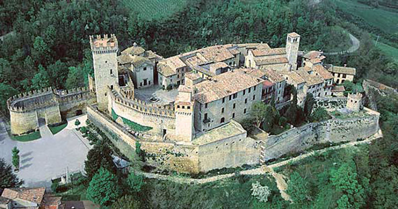
Vigoleno (Vernasca) - The Medieval Borgo
A stroll in the Medieval Times.
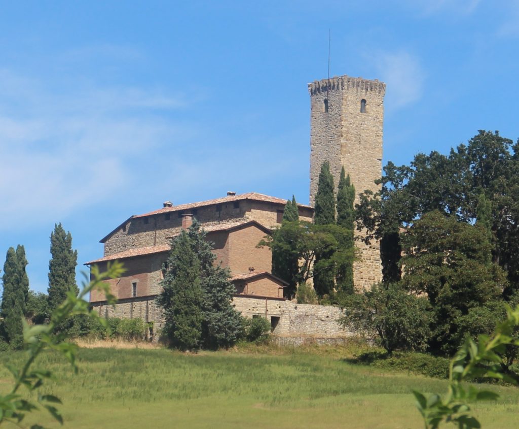
Castle of Contignaco, Aldighieri's Fortress
Adalberto Pallavicino built the fortress during the XI century and seems that its main tower 30 meters high was built in 1030.
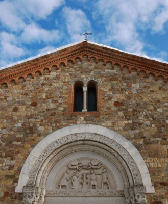
San Giovanni in Contignaco Parish Church
On the top of the hill was built, in pre-Roman times, the church of St. John. Inside you can admire frescoes from the 14th and 15th centuries and pictorial testimonies of a singular local artist.
San Vittore Church
The church was initially called "Plebs Curticellis", a name that can be traced according to some sources to the name of the town of San Vittore in medieval times, "Corticelle", according to some hypotheses as it was included in one of the small courtyards in which the territory was divided.
Castle of Tabiano
The Castle was built during XII and XIII centuries and was completly renewed at the end of XIX century when it was reconverted in a private house.
Church of S.S. Gervasio and Protasio - Tabiano Castello
The small church of Tabiano Castello is dedicated to the saints Gervasio and Protasio.
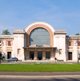
Modern Architecture - Railway Station
The railway station clad in pink and white travertine was an expression of artistic and urban movements typical of the 20th century. Designed by the engineer Cervi, who took his inspiration from Milan’s central station, the building was inaugurated in 1937.
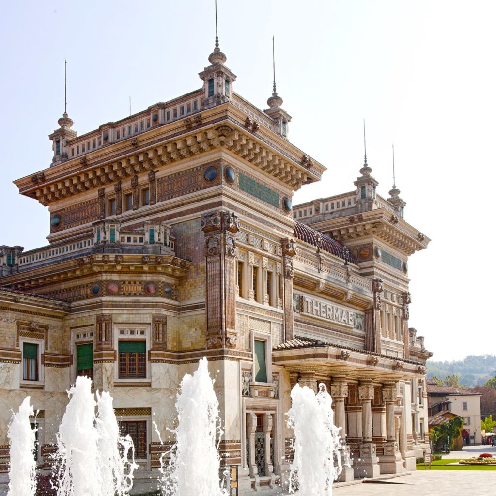
Liberty Building - Lorenzo Berzieri Thermal Spa
The Berzieri Palace is one of the most complex and fascinating building of the thermal city, landmark of the European thermalism and unique example of thermal Art Decò style. The liberty palace is counted in the Emilia Romagna Cultural Heritage.